Kings Hill/Southwest Salmon Street station
| MAX Light Rail station | ||||||||||||||||
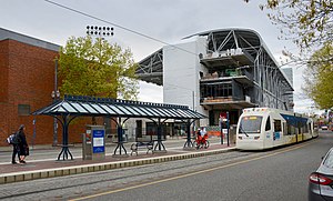
 Viewed from the south in 2019 with the Multnomah Athletic Club and Providence Park in background | ||||||||||||||||
| General information | ||||||||||||||||
| Location | SW 18th Avenue and Salmon Street Portland, Oregon, U.S. | |||||||||||||||
| Coordinates | 45°31′13″N 122°41′28″W / 45.52028°N 122.69111°W | |||||||||||||||
| Owned by | TriMet | |||||||||||||||
| Line(s) | ||||||||||||||||
| Platforms | 1 island platform | |||||||||||||||
| Tracks | 2 | |||||||||||||||
| Construction | ||||||||||||||||
| Accessible | Yes | |||||||||||||||
| Other information | ||||||||||||||||
| Status | Closed | |||||||||||||||
| History | ||||||||||||||||
| Opened | August 31, 1997 | |||||||||||||||
| Closed | March 1, 2020[1] | |||||||||||||||
| Suspended services | ||||||||||||||||
| ||||||||||||||||
| ||||||||||||||||
Kings Hill/Southwest Salmon Street is a former light rail station in Portland, Oregon, United States, which was served by the Blue and Red lines of TriMet's MAX Light Rail. The station was situated within the Goose Hollow neighborhood. Its incorrectly punctuated name refers to the hillside to the west of the station, which has historically been referred to as King's Hill.[2] A section of King's Hill, which contains many historic buildings, qualified for inclusion within the King's Hill Historic District, the easternmost boundary of which is at SW 21st Avenue.[3]
Description and history
[edit]
The station is located in the center of SW 18th Avenue and has a single platform between the tracks. The platforms are accessed from the left-hand side of the train.
Despite the Providence Park eastbound station being only two blocks away, the station was added at the request of the neighborhood. It provides service to Lincoln High School and the Multnomah Athletic Club. Though one of the least-used downtown MAX stations, in 2006 a new condominium development nearby was expected to boost ridership.[4]
On March 1, 2020, TriMet closed the station, alongside the stations at Pioneer Place mall, as part of a pilot program to improve MAX journey times through Downtown Portland.[5][6] While the station was supposed to be closed for only a year, it has remained closed since.[7]
Public art
[edit]Artwork around the station recalls Tanner Creek, which was buried and infilled early in Portland's history, and a bronze goose paying tribute to the Goose Hollow neighborhood. The Simpsons creator Matt Groening etched Bart Simpson into the east sidewalk of SW 18th Avenue in 1996 during the construction of this station. The City of Portland has opted to leave the sidewalk intact. SW 18th Avenue runs behind Lincoln High School, where Groening graduated in 1972.
Bus line connections
[edit]When in operation, this MAX station was served by the following bus lines:
- 15-Belmont/NW 23rd Ave
- 51-Vista
- 63-Washington Park
References
[edit]- ^ Altstadt, Roberta (January 24, 2024). "TriMet proposes improvements to make MAX system faster and more reliable". TriMet. Retrieved January 25, 2024.
- ^ Prince, Tracy J. (2011). Portland's Goose Hollow. Charleston, South Carolina: Arcadia Publishing. ISBN 978-0-7385-7472-1.
- ^ "King's Hill Historic District Guidelines" (PDF). Planning Bureau, City of Portland. 2001. pp. 133–138. Retrieved June 13, 2011.
- ^ Cost of prime site with MAX access: $1 Portland Tribune, August 22, 2006.
- ^ Altstadt, Roberta (January 24, 2024). "TriMet proposes improvements to make MAX system faster and more reliable". TriMet. Retrieved October 6, 2024.
- ^ Theen, Andrew (February 25, 2020). "2 downtown MAX stations close permanently next week; changes coming to more than a dozen TriMet bus routes". The Oregonian. Retrieved October 6, 2024.
- ^ Altstadt, Roberta (January 24, 2024). "TriMet proposes improvements to make MAX system faster and more reliable". TriMet. Retrieved October 6, 2024.
External links
[edit]- Station information (with northbound/eastbound ID number) from TriMet
- Station information (with southbound/westbound ID number) from TriMet
- MAX Light Rail Stations – more general TriMet page

